info@chieseromaniche.it
Home
Novità
In evidenza
Il Progetto
Ricerche
Per Comune
Per Provincia
Per Quadrante
Per Itinerario
Per Nome della chiesa
Per Periodo
Per Interesse
Selezioni
Architettura
Campanile
Pittura
Cripta
Risorse
Gallerie Fotografiche
Raccolta Newsletter
Glossario
Agiografia
Documenti
Bibliografia
Sitografia
Mappa Chiese
Mappa Regionale
Mappa Provinciale
Referenze
Elenco Chiese
Referenze fotografiche
Autori Foto
Pubblicare
Contatti
Chiese Romaniche, Gotiche e Rinascimentli nei dintorni
home
Mappa chiese dintorni
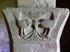
Ex cappella del Cimitero a Ayas
Scegli il raggio in cui cercare le chiese
Seleziona il raggio in chilometri
5
10
15
20
25
30
40
50
60
Ex cappella del Cimitero a Ayas
Elenco chiese nei dintorni
In un raggio di 30 Km
in linea d'aria
San Martino - AYAS
(0 Km)
Percorso
Scheda
San Giacomo Maggiore - AYAS
(6,4 Km)
Percorso
Scheda
San Maurizio - BRUSSON
(6,8 Km)
Percorso
Scheda
San Maurizio - SAINT-VINCENT
(7,2 Km)
Percorso
Scheda
San Vincenzo di Saragozza - SAINT-VINCENT
(7,5 Km)
Percorso
Scheda
Sant'Andrea - ANTEY-SAINT-ANDRÈ
(7,5 Km)
Percorso
Scheda
San Pietro - CHÂTILLON
(9,2 Km)
Percorso
Scheda
San Maurizio - BRUSSON
(9,7 Km)
Percorso
Scheda
Saint Germain - MONTJOVET
(9,9 Km)
Percorso
Scheda
San Martino - PONTEY
(11,1 Km)
Percorso
Scheda
Sant'Erasmo - SAINT-DENIS
(11,3 Km)
Percorso
Scheda
San Giovanni Battista - CHALLAND-SAINT-ANSELME
(11,7 Km)
Percorso
Scheda
Santa Maria al Borgo o Na - MONTJOVET
(12 Km)
Percorso
Scheda
San Maurizio - SAINT-DENIS
(12,2 Km)
Percorso
Scheda
San Massimo - CHALLAND-SAINT-VICTOR
(12,6 Km)
Percorso
Scheda
San Lorenzo - CHAMBAVE
(13,1 Km)
Percorso
Scheda
San Vittore - CHALLAND-SAINT-VICTOR
(13,6 Km)
Percorso
Scheda
San Martino e Santa Lucia - VERRAYES
(13,4 Km)
Percorso
Scheda
San Martino e Santa Barba - VERRAYES
(13,4 Km)
Percorso
Scheda
SS. Egidio e Agostino - VERRÉS
(15,9 Km)
Percorso
Scheda
San Michele - VERRAYES
(14 Km)
Percorso
Scheda
San Gilles o Sant'Egidio - VERRÈS
(15,9 Km)
Percorso
Scheda
Saint-Solutor - ISSOGNE
(16,4 Km)
Percorso
Scheda
Saint-Barthélemy - NUS
(16,4 Km)
Percorso
Scheda
Castello - ISSOGNE
(17,6 Km)
Percorso
Scheda
San Maurizio - FÉNIS
(18 Km)
Percorso
Scheda
San Martino - ARNAD
(18,7 Km)
Percorso
Scheda
San Giacomo Maggiore - ISSIME
(19,1 Km)
Percorso
Scheda
San Giovanni Battista - ALAGNA VALSESIA
(19,7 Km)
Percorso
Scheda
Madonna delle Nevi - ARNAD
(20,2 Km)
Percorso
Scheda
San Michele - RIVA VALDOBBIA
(20,6 Km)
Percorso
Scheda
Santa Margherita - BIONAZ
(21,7 Km)
Percorso
Scheda
Sant'Antonio Abate - FONTAINEMORE
(22,5 Km)
Percorso
Scheda
Assunzione di Maria - BARD
(23,1 Km)
Percorso
Scheda
San Rocco - LILLIANES
(23,3 Km)
Percorso
Scheda
San Salvatore - PERLOZ
(23,9 Km)
Percorso
Scheda
San Pietro in Vincoli - DONNAS
(24,1 Km)
Percorso
Scheda
Notre-Dame-de-le-Garde - PERLOZ
(24,4 Km)
Percorso
Scheda
Fontaney della Beata Verg - PONT-SAINT-MARTIN
(24,9 Km)
Percorso
Scheda
San Martino - PONT-SAINT-MARTIN
(25,1 Km)
Percorso
Scheda
Saint Christophe - SAINT CHRISTOPHE
(26,7 Km)
Percorso
Scheda
Saint Christophe - SAINT CHRISTOPHE
(26,7 Km)
Percorso
Scheda
Vecchia - MACUGNAGA
(27,5 Km)
Percorso
Scheda
Vecchia - MACUGNAGA
(27,5 Km)
Percorso
Scheda
Sant'Orso - AOSTA
(29,3 Km)
Percorso
Scheda
Sant'Orso - AOSTA
(29,3 Km)
Percorso
Scheda
San Vittore - ROISAN
(29,3 Km)
Percorso
Scheda
San Vittore - ROISAN
(29,3 Km)
Percorso
Scheda
Sant'Orso - AOSTA
(29,3 Km)
Percorso
Scheda
Sant'Orso - AOSTA
(29,3 Km)
Percorso
Scheda
Priorato di Sant'Orso - AOSTA
(29,3 Km)
Percorso
Scheda
Priorato di Sant'Orso - AOSTA
(29,3 Km)
Percorso
Scheda
San Biagio - DOUES
(29,6 Km)
Percorso
Scheda
San Biagio - DOUES
(29,6 Km)
Percorso
Scheda
Madonna del Ponte - BOCCIOLETO
(29,8 Km)
Percorso
Scheda
Madonna del Ponte - BOCCIOLETO
(29,8 Km)
Percorso
Scheda
Notre Dame de Pitié - CHARVENSOD
(29,9 Km)
Percorso
Scheda
Notre Dame de Pitié - CHARVENSOD
(29,9 Km)
Percorso
Scheda
Seleziona altro raggio
Ex cappella del Cimitero a Ayas
Mappa delle 59 chiese nei dintorni
In un raggio di 30 Km in linea d'aria
Chiesa Selezionata
Chiese con Foto
Da fotografare
Mia Posizione
Visualizza anche la mia posizione
Itinerario
da
Ex cappella del Cimitero - Ayas
a
Chiesa di Saint-Solutor - Issogne
Seleziona altra destinazione